Just got the Garmin 705 in the week after breaking my Polar CS200 when I threw the bike in the car after the chain snapping escapade. Its obviously a very capable tool but I have to say the instructions are pretty basic.... it's on the web for help from the community.
It was up at 05:00 stuffing cold rice pudding into the system... nice ! load up the gear, the bike and then off to pick up Gaz and Pete, we were on our way at 06:20. Arrived at the start at 07:30 for registration. After the shock of the car park fee £6 we settled down to getting ready. The weather was cold but clear once it came light.
The route took us out of Grassmere straight up Red Bank at 25%, bit of a shock when we hit the ice on the up slope, so it was off the bike, restarting on the slope was interesting ! The descent was not too icy. Thereafter, every time we crossed any run-off from adjacent fields they were frozen so great care was required. The route took us to Consiton, down the east side of the lake along the route of the Coniston 14 running race and then on to Haverthwaite, across the A590 to Cark then past Bigland Estate to Flookborough into a fierce headwind. We stayed together mainly but I have to confess to getting on the back of a 3 man breakaway group for the 6 mile run into Flookborough, it was fast.
The food stop was excellent, clearly the organisers had catered for about 300 riders but less than half has shown, this probably due to the deferral process deadline of 19th December 2008. Didn't really need to stop but what the hell, it was a social ride. Stopped for about 30 minutes
 The stop was at the low point of the elevation profile above. Straight out of the food stop we were faced with a 25% 'wall' that nobody had mentioned ! Then it was the climb ove
 r Bigland, across the A590 and north through Grizedale Forest, Salterthwaite, Outgate, outskirts of Ambleside, Rydal Water and home.
We came in 88th / 89th and 90th out of a field of 140with an elapsed time of 4h 35m and a ride time of 3h 58m.... maybe we shouldn't have stopped !! We did well to avoid the snow which came in later that afternoon.
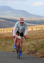
This is Gaz just coming into the finish, still smiling ! The christmas pudding and custard went down very well. So the stats..... The Garmin advised 56.5 miles but further investigation reveals that the Garmin reads about 4% low on a bike this is due to the 'fix' rate, about every 100m so the curves don't get measured. In a very rural setting this can be quite a loss. The ride is quoted at 58.5 miles consistent with this shortfall. Calories burned 4041, average speed 14.4 (slowed due to the ice - my excuse and I'm sticking to it), total ascent 4,350ft or 1,326m, reasonable for the time of year.
Till next time.....

2 comments:
That's a good average speed with the hills and ice. Interesting comment about the Garmin measuring short on a bike. I imported my last MTB route from my 305 into Memory Map and it seemed to cut loads of the bends off.
Sorry, didn't see your comment till just now. This Garmin short measure bit seems to be seldom mentioned. Now I routinely add between 4 and 6% to my Garmin distances.
Post a Comment